The people at NASA say that parts of New York City are sinking, and are claiming that this is the reason for New York’s recent flash floods. Are people really that stupid? Even assuming that this has been going on that long, New York has only sunk nine and a half inches since the Civil War, only about 5/8 of an inch per decade. Still, I can prove that to be a lie with a couple of pictures. Here are two photos of Whitehall Terminal, where the Staten Island Ferry departs from Manhattan, taken about 60 years apart. The first was taken in 1956, pay special attention to the water level in comparison to the waterfront to the left of the building:
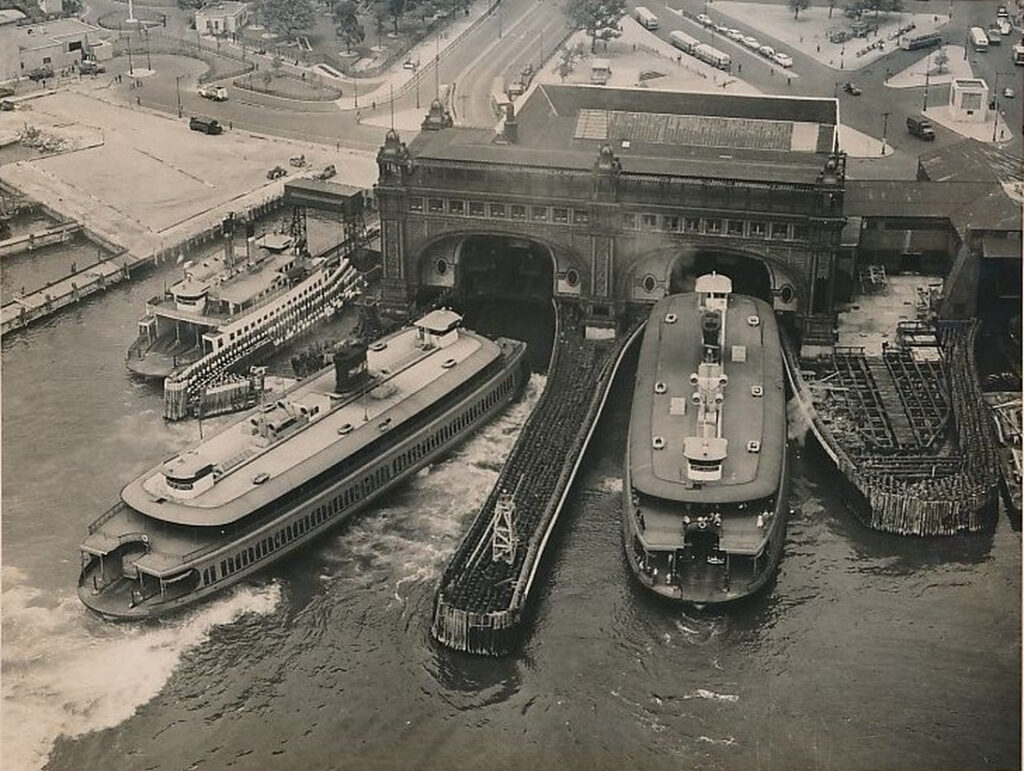
Now the same building, taken in 2014:

Can you see a difference? Of course you can’t. Do you want to know why New York flooded this week? Because they had more than 7 inches of rain in less than 48 hours.
The article goes on to say that the ocean will rise an average of .04 inches by the year 2100. Four hundredths of an inch in 77 years. That means nothing. In fact, that works out to an average of 0.005 inches per year, or 0.127 millimeters per year. We can’t even measure ocean rise at that level, it’s physics.
The margin of error for the synthetic aperture radar that they are using to measure the ocean is one twentieth of the wavelength of the radar doing the measuring under perfect conditions, but is actually less due to atmospheric conditions. The wavelength of Ku band SAR is 17 to 24 mm, making the maximum precision to be plus or minus 1 mm. So NASA is claiming to be able to measure ocean height changes that are more than 8 times smaller than what they are physically capable of measuring.
In summary, we don’t know if the ocean is rising or not, because even if it is, we don’t have a way of measuring the small amount that it is rising, and even if it is be rising, it is doing so at such a slow rate that it will only rise about half an inch in the next eight hundred years. This is all a scam that is being designed to whip morons into a frenzy, so that they can be more easily manipulated.
13 Comments
nones · October 2, 2023 at 5:11 am
Because…well…because climate change. The brainwashing is complete. Morons they are but one of these days, if The US of A survives, one of these morons will be running the show. Some of these morons will make our current moron (FJB) look like a frickin’ genius.
Joe Blow · October 2, 2023 at 5:23 am
“This is all a scam that is being designed to whip morons into a frenzy, so that they can be more easily manipulated.”
Birdog357 · October 2, 2023 at 6:37 am
Parts of the city are sinking though, it’s landfill, and that settles. Has nothing to do with the ocean levels, it’s sinking relative to bedrock.
WDS · October 2, 2023 at 7:41 am
There’s an area downtown in Columbia SC that floods out 80% of the time there’s a heavy summer downpour. It ain’t climate change either, more like poor planning and drainage issues. Ask any USC student and like good little robots they’ll echo the climate change narrative almost verbatim.
Bear Claw · October 2, 2023 at 9:20 am
Let me know when Ellis island and Plymouth Rock are submerged, then we can celebrate
Aesop · October 3, 2023 at 3:27 am
^That. Right there.
And this:
https://i.imgur.com/8t606JZ.png
WDS · October 3, 2023 at 8:06 am
As a former Masshole and specifically a Plymouth resident, I can attest this image is correct. Damn, I could go for a lobster roll or some fried clams now.
poppi · October 2, 2023 at 10:42 am
The tidal range at The Battery, where the photo of the Staten Island Ferry terminal was taken, is about 4-6 feet; the water level
varies by that much twice each day, as the moon orbits around the earth. As the orbit of the moon also gets closer or further away
during the month ..apogee and perigee.. the daily variation is even more. Periods of low atmospheric pressure will suck in water
from surrounding areas, raising the water level (that was what happened during Hurricane Sandy; water levels were 13 feet higher
than normal because the storm’s low pressure eye acted like a vacuum cleaner, and the onshore winds pushed ocean water into the
bay. It was quite a sight later to watch it getting flushed out like a toilet after the storm had passed – the inertia of the water leaving
pulled additional water out to sea, drastically lowering the water height & temporarily exposing more of the seabed.)
The normal range of water depth is not caused by the oceans rising, nor by the land sinking. Although this particular stretch of
shoreline is landfill for about two streets inland, most of Manhattan is solid rock. It is possible that the near shoreline is slowly
compacting and slumping into the water, I’ve read that Galveston TX & parts of the Louisiana coast have done so, possibly due to
petroleum extraction. Kuala Lumpur is also sinking, and at a much faster rate than “Globul Warming” would cause. Maybe that slow subsidence is what causes them to believe the water is rising.
So, why did New York flood this week? Because the storm sewers haven’t been cleaned of debris and clogs, because the drain
grates are covered with litter, because this was an extraordinary event with 7 inches of rain.
Brooklyn and Queens, where there was much flooding, have a different geology from Manhattan; the terminal moraine of Long
Island is nothing but sand for 2 hundred feet down before hitting solid rock; storm sewers are built by digging a trench and then
placing three foot diameter concrete pipe, and backfilling it with sand. But leakage from the sewer pipe frequently washes away the
supporting sand, creating sinkholes which cause the pipe to collapse. Now the street above collapses, and the storm sewer gets
filled with more sand further reducing its drainage capacity. In Park Slope Brooklyn, the sewers collect water from nearly one
square mile of hillside land, it all runs downhill to Fourth Avenue, which is flat land about ten feet above sea level (also where the
subway is thirty feet below street level); it empties out into the canals nearby, but an extreme event like the recent storm easily
overwhelms the carrying capacity of the sewers, geysering up from the manholes making a three foot deep lake, before rolling down
the shallow hill to the canals. The subways are not a sealed tube, there are ventilation shafts and sidewalk grates everywhere, which
allowed the flood into the subway; being below sea level, it had to be pumped out.
The next question is .. WHY aren’t the sewers cleaned, maintained and repaired?? NYC’s budget is well over ONE HUNDRED BILLION DOLLARS per year; surely the City Council could cut a billion from somewhere, and use it for one of the most important core obligations of any government .. providing clean water and effective waste water management.
The normal range of tides & storm surges, coupled with the inherent inaccuracy of the measurement equiptment is much much
greater than any claimed “rise in sea levels caused by globul warming”; I can’t be bothered by a one millimeter “rise”, when the
normal range form ordinary and extraordinary events is a thousand times greater. But I am greatly annoyed by the incompetence of a single party local government, more devoted to their ideology and cult, more swayed by a small group of very vocal environmentalists, more indifferent to the common sense needs of ordinary people in New York.
Beans · October 2, 2023 at 11:44 am
There are actually places that are seeing ‘rising waters,’ due, of course to sinking land. Like some sections of NYFC, or New Orleans, or Venice (Italy.)
Funny how those all are claimed under ‘rising sea waters due to climate change.’ No, sinking places due to crappy landfills and rotten base layers. Duh.
Pace Picante Sauce · October 2, 2023 at 1:53 pm
The original aggregator had a (wink nudge) in the headline about Rome falling due to massive IQ drop over time.
Hmm…so hmm.
Muh Magic Soil says that we are going to be in Moscow by winter and Beijing by spring and the new armed forces apparatchik who seeks to purge all whites will lead the glorious march down the Volokolamsk Highway to seize that gas station with an economy and redistribute all spoils as reparations!
Sorry, April Fools is a long way away.
numbersrunner · October 2, 2023 at 2:03 pm
I do not claim to be a stupid New Yorker or a stupid reader, but I reject the author’s pictures as proof of changes in water levels. Unless those pictures were taken at the same time of day, I would suggest that tides would cause greater differences within one day than are claimed for the 58 years between the shots. I agree with his logic otherwise, but suggest he might have spent more time reviewing his figures and his math.
Tree Mike · October 3, 2023 at 7:00 am
RREEEEEEE!!!!! PANIC!!!!!! IT’S OUR ONLY CHANCE!!!!!
Paulb · October 5, 2023 at 2:22 pm
There’s lots of stuff going on. As others said, NY has a lot of fill. Plus, Cape Cod, Long Island and Sandy Hook are just dump piles of sand left by the last glacier. Of course they’re washing away… but while that’s going on, the bedrock is rising still as it decompresses from the glaciers during the last ice age. I can’t speak for NY, but most of New England is rising about 1″ per century now.
Now, all that is background. I’m in NY harbor right now as we speak, and trying to run a big goddam boat. After that last rainstorm, the tides were affected. Not only was the time of tide off by almost 30 minutes for 2 days, the max flood and ebb times (the time when the current is at its’ maximum) were way off, and the high tide height was off- there was so much runoff from the rain that the East River and Hudson river, where they dump out by Buttermilk Channel in the harbor that it backlogged and formed a standing wave where it met the harbor proper.
When you hear that a coastal area is sinking, more often than not it’s some state-school fuckup who mistook the tide charts for a bible. The sort of guy who couldn’t get a placement in a good grad school for cause, and had to go to the USGS or NOAA, doing a chicken little. They are NOT the best and brightest. Changes in the tidal predictions are usually caused by local conditions, like flooding, and the tide charts need to be rerun or disregarded until normal conditions are reestablished. That’s all.
Comments are closed.